Tephrabase: Grímsvötn Eruption 21 to 28 May 2011
Volcanic Eruption, Grimsvotn, Vatnajokull (glacier), Iceland May 21 2011 from Jon Gustafsson on Vimeo.
This page was originally written immediately after activity ceased. Volcanic activity reports can be found University of Iceland's Institute of Earth Sciences' Grímsvötn 2011 page. A wealth of information about Grímsvötn and other Iceland volcanoes and their eruptions can be found at the Catalogue of Icelandic Volcanoes website.
The eruption column height dropped to around 10km later on Sunday 22nd May and the 23 May Status Report reported that it had dropped to between 5-9km. On the 24 May, the London VAAC were reporting that the ash plume was around 5km in height and both the lightening and seismic activity at Grímsvötn reported by the Icelandic Meteorological Office was much reduced. All of these showed a waning in the eruption intensity. This was an intense eruption, much larger than any recent activity in Iceland. This was a tholeiite-basalt eruption, with initial whole rock analyses showing a SiO2 content of between 50-51%. Basaltic eruptions are usually effusive (ie not explosive), but the violent interaction between water (melted ice from the overlying ice cap) and the magma mean that steam explosions occur which fragment the magma into tephra (volcanic ash). This geochemistry and type of eruption is typical for Grímsvötn.
The 23rd May Status report also reported that a large glacial flood was unlikely, as the eruption is in the same location as the 2004 activity and the ice is relatively thin.
The 24th May Status report confirmed that activity had decreased from the initial intense phase of the eruption. The eruption column was generally no higher than 5km and the Icelandic Meteorological Office were using a portable weather radar to monitor the plume. The main tephra axis is to the south/south south west, with the tephra clouds mainly between Lomagnupur and Myrdalsjökull, although Kirkjubaejarklaustur experienced much decreased tephra fall. No earthquakes were reported during the last day, but the eruption tremor remained stable.
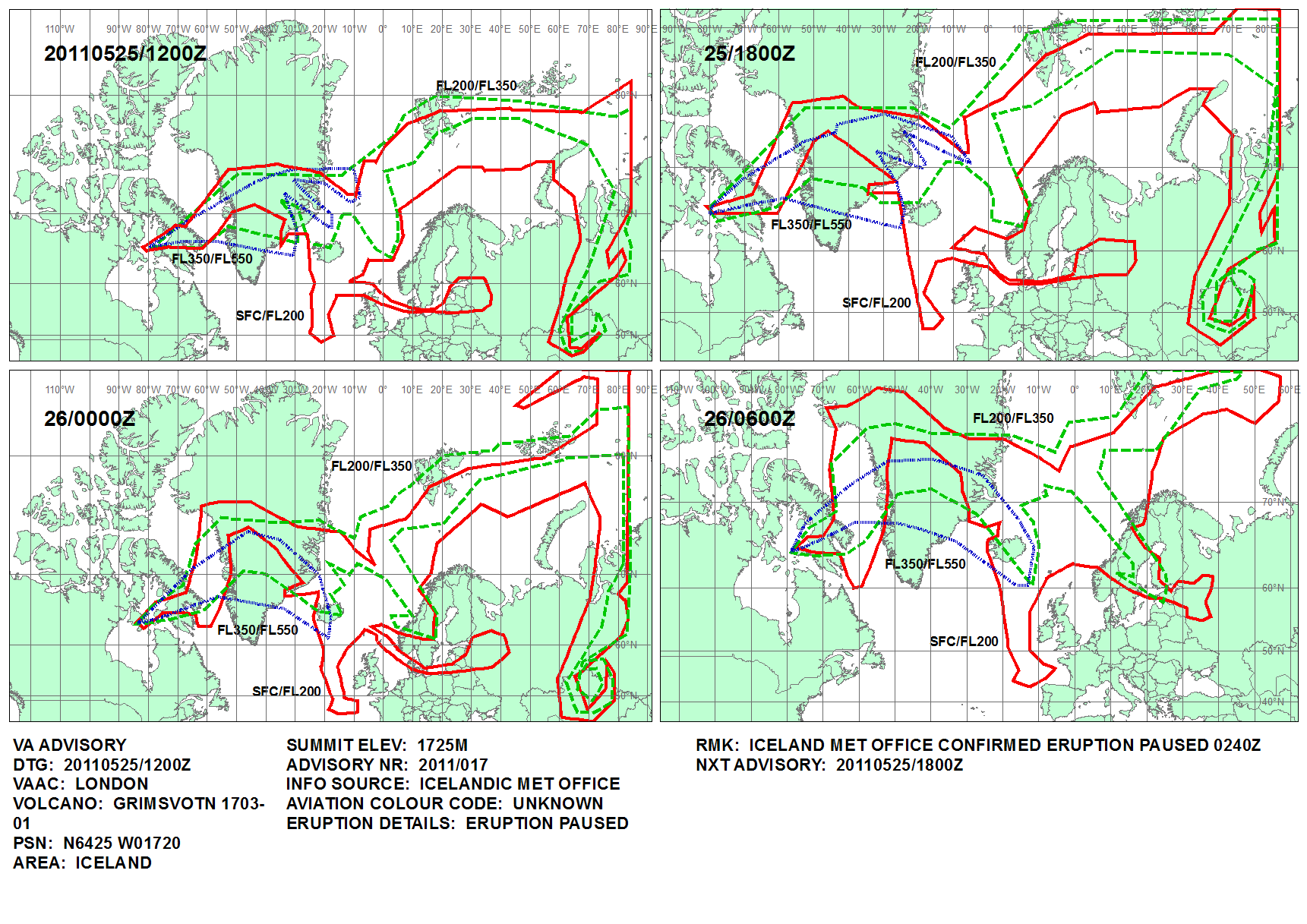
The Icelandic Meteorological Office's Tremor graph showed a dramatic drop in the intensity of the eruption in the early hours of the 25th May. London VAAC confirmed that the eruption is currently paused since 02.40 25 May. The status report issued on the 25 May confirmed that activity had dramatically reduced to small scale explosions, with only local tephra deposition. Relatively little ice appears to have been melted, again suggesting that the chances of a large flood were much reduced. The 26 May Status Report confirmed that there was very little limited activity in the crater, with little change from the 25 May and the explosions that were occuring were only depositing tephra locally.
The 30th May Status Report confirmed the end of the eruption as being 07:00 May on 28th May when the eruption tremor stopped.
Ash Fall and Collection
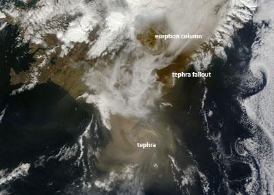
NASA’s Terra satellite MODIS image taken at 13:00 UTC on May 22, 2011. (Image NASA/GSFC, MODIS Rapid Response)
Unlike last year, meteorological conditions have been very changeable and it was difficult to be certain about the exact distribution or timing of the arrival of the ash cloud. However, the London VAAC were able to predict that UK airspace would be affected by ash on Tuesday 24th May. This lead to will be cancellations and delays, especially in Scotland. However, planes are now allowed to fly in denser concentrations of ash than last year and we also now have better monitoring systems in place to provide an accurate picture of where the ash is. As of Wednesday 25 May the ash cloud has moved over towards Denmark and norther Germany, leading to grounded flights and delays.
It is very useful to have data on where the ash actually falls to the ground and the British Geological Survey (BGS) are coordinating UK wide collection of ash from the Grímsvötn eruption. This is very easy to do and would greatly help our understanding of how ash is transported through the atmosphere. Details on how to do this can be found at the BGS Grímsvötn Ash Collection website and a helpful video can also be found on the volcan01010 blog. If you are collecting the ash please do not worry if you cannot see any on the tape, it is likely to be very small and not necessarily visible to the naked eye. It is not certain how much fallout there will be in the UK, but it will also be useful to know where it has not fallen. BGS have also launched a BGS E-Mail Volcanic Ash Questionnaire and the results are available on to view on a map. This shows where there have been reports of ash fall and where there have not. Obviously this needs to be treated with some caution, as it is easy to misidentify volcanic ash.
Useful Links
- Institute of Earth Sciences and the Nordic Volcanological Centre, University of Iceland
- Eruption in Grímsvötn 2011
- Geochemical data
- Status Report 30 May 2011
- Status Report 26 May 2011
- Status Report 25 May 2011
- Status Report 24 May 2011
- Status Report 23 May 2011
- Status Report 22 May 2011
- Icelandic Meteorological Office
- Tremor graph from Grímsvötn
- Update on volcanic activity in Grímsvötn
- Ash plume and lightning
- Photographs of the eruption
- London VAAC
- British Geological Survey Grímsvötm 2011 Resources
- IVHHN - The International Volcanic Health Hazard Network
- John Stevenson's volcan01010 Blog
- EUMETSAT satellites observe Grímsvötn volcanic cloud
- NASA Earth Observatory Satellite Images